GPS
Dewesoft GPS Acquisition module offers the possibility to acquire GPS data. Depending on the used GPS system, different data is available like position, velocity, available satellites, and many more. GPS systems are used to determine the position on earth, velocity and absolute time.
- Required hardware (VGPS - HS, VGPS-HSC, VGPS, Leane VSAT, Javad, Microsat or any NMEA compatible GPS)
- Setup sample rate - At least 1 kHz
For additional help with GPS Acquisition visit Dewesoft PRO training -> Dewesoft Web page -> PRO Training .
For additional Dewesoft manuals visit -> Dewesoft Web page -> Support -> Downloads.
When you select GPS tab on Dewesoft Setup screen, on lower part of screen GPS settings will appear:
- GPS channel list - with information about GPS channel Slot number, On / Off state, Name, Value column and primary SETUP column with Setup button to call GPS channel setup window
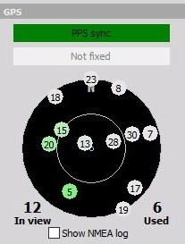
- GPS information - display information about all inView and Used satellites constellation on the sky, PPS synchronization, SBAS or WAAS Differential mode and to show NMEA log information

After GPS channel setup is done press the Unused button - it will change now to Used - to switch on the acquisition.
GPS channels which are available (all channels are not available with specific types of receivers):
- X absolute - current longitude (the position from Greenwich - prime meridian, positive is east). Raw data in the data file is in minutes (from example above 15*60+3=903)
- Y absolute - current latitude (0 degree is equator, positive is north) raw data in the data file is in minutes (example from above 46*60+10=2770)
- Z - in meters
- Velocity - vector velocity of movement
- Velocity Z - velocity in Z coordinate
- Direction - direction of travel (0 is north)
- Distance - traveled distance calculated from velocity
- Used satellites - number of satellites used in GPS solution
- Current sec - number of elapsed seconds from midnight
- Mark input - status of external signal input (used sometimes for brake switch)
- Acceleration - current acceleration vector calculated from velocity
- GPS fix quality - description of GPS fix - only available for some receivers, it could be Standalone, WAAS/EGNOS sat differential, RTK float and RTK fixed. Second receives data from fixed satellites while the last two require differential data from the base station. RTK fixed is the best possible solution providing cm accuracy of the solution.
- NMEALog - raw text messages coming from GPS
GPS channel list
First let‘s look at the columns that are shown in the GPS channel list, and describe what each is for:
- SLOT - GPS channel input slot
- ON/OFF – activate/deactivate GPS channel - press the Unused button - it will change now to Used - to set the desired GPS channel active for GPS data acquisition and they are available in all instruments either as digital values or graph
- C– channel color selector - this color will carry through the text and graph representations of this channel throughout all DEWE software procedure screens
- NAME – GPS channel name - just click into the NAME field and you can enter the new name as usual text
- VALUE – current GPS channel value
- SETUP – GPS channel settings (see below)
For information about Slot, On/Off, C and Name see -> Setup -> Channel grid.
GPS channel setup
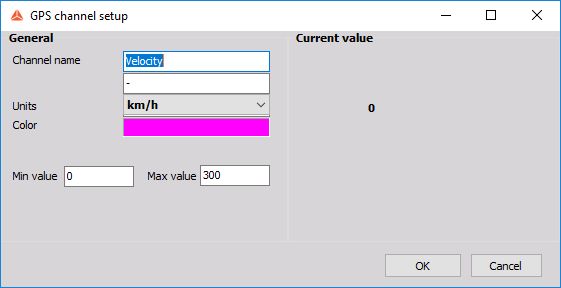
Press the Setup button of the GPS channel you want to change. The following GPS channel setup window will open:

In the General part of GPS channel setup screen you can enter:
- Channel name - can be Velocity, Distance, Coordinates,… and are entered as text
- Units - of measurement value: m, km/h,… are entered as text
- Color - of displayed channel - simply click on the colored field to open the color selector
- Min value, Max value - fields represent a definable standard display range and are entered as text
Edit and navigation keys are same as in other Windows application.
On right part of GPS channel setup window Current value of channel is displayed.
GPS information
Satellites information
On the bottom we have a sky map, which shows the current satellites constellation on the sky. The satellites which are currently used are drawn in green (if the receiver supports GLONASS, then the satellites are shown in red) and the color shows the strength of the signal. Pale green means weak signal and dark green is strong signal.
Under GPS Satellite map field is number of All satellites on the left and Used satellites on right.

Other GPS information
Whit PPS sync indicator we have information if PPS synchronization is available. This is information about the receipt of the pulse per second signal over the GPS interface (RS232 or USB), which can, if it is available, enhance synchronization to other data source.
If the receiver supports differential mode from SBAS or WAAS and differential mode is used in Hardware setup, this will be shown in Differential mode indicator. If this indicator is dark green, differential (higher accuracy) mode is used.
We can display GPS log information with Show NMEA log button. This function is used to see specific messages from the GPS receiver.